Nebraska K-12 GIS Education Initiative
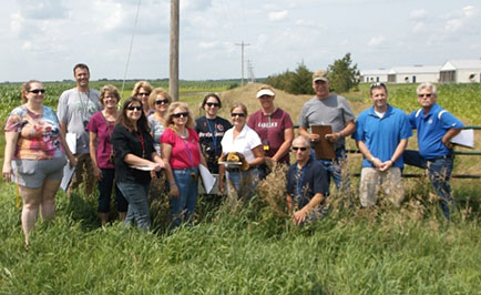
Pictured is a group of teachers attending the Wakefield, Nebraska workshop. Photo courtesy of Kathy Wilke.
The Nebraska Department of Education and the Office of the CIO recently partnered to bring free GIS software and online mapping service through a statewide educational enterprise license agreement (ELA) with Esri. This provides software and online instruction for all K-12 schools, districts, staff, students, and formal youth clubs in the state. This software and service is valued at $80,000 per year. This includes GIS software for desktop, server, ArcGIS Online, and mobile use. It provides updates to software, technical support, online instruction, and complimentary registrations to the annual Esri User Conference.
The success of the pulling off the implementation for a statewide curriculum and GIS plan for K-12 is to find the right teachers with the interest and support from their organization. To jump start the use of the software and the program, the curriculum and technology needed to be exposed to interested teachers. Earlier this year, the Nebraska Department of Education was successful in receiving a grant from the Nebraska Environmental Trust to develop curriculum around soil conservation with the stipulation of using GIS to deliver the curriculum. The project is entitled, “Educating the Next Generation of Nebraskans About Soil Conservation Using the Power of Geographic Information Systems (GIS).” The Nebraska Environmental Trust awarded the State of Nebraska Department of Education a grant for 3 years totaling $88,881 to develop, deliver and maintain curriculum.
Since then, curriculum was developed and five teacher training workshops were conducted through June and July in Omaha, Scotts Bluff, North Platte, Kearney, and Wakefield. More than 90 teachers were instructed on how to take the information from the field and utilize GIS software to create a computer document called a story map. Story maps combine intelligent Web maps with Web applications and templates that incorporate text, multimedia, and interactive functions. Each story map in the workshops followed the theme of soil conservation practices and consisted of photos showing conservation practices, a narrative written to explain the photos and a computerized GIS map. The GIS map showed where the photos were taken and allowed the user to select information from that location to see pictures that were taken about soil conservation. You can see examples of these story maps by visiting the project’s online mapping resource page for teachers at http://needgis.maps.arcgis.com.
The workshops also provided resources to get students excited about GIS and careers in the field. These workshops will be conducted again for the next two consecutive summers throughout the state. During the next school year, the process of creating story maps will also be taught by some of the workshop’s teachers in classrooms across the state. The end result will be classrooms visiting sites in their local community and creating story maps that help young people to understand soil conservation practices and the use of GIS technology.
The planning team for this initiative is currently working on a series of webinars for this fall to assist teachers who are interested in getting involved and setting up online mapping accounts with this initiative. A project web page and teacher workshops for next summer are currently being planned.